Shaping Trenton’s future starts with you. Read an introduction to Trenton250.
-
Background
-
Background
-
Background
Learn more about the Plan and how it is organized
-
Master Plan Requirements
Learn about the legal requirements for the Master Plan and what Reports the City plans to write
-
Outreach Summary
Learn more out the robust public engagement effort
-
Foundational Materials
Previous studies and planning efforts
-
Consultant Teams
-
-
Citizen's Guide
-
Citizen's Guide
-
Citizen's Guide
Learn more about the Plan and how to use it
-
Frequently Asked Questions
Get answers to your most frequently asked questions
-
Listening Tour
Watch a video about the Master Planning Process
-
-
The Plan
-
The Plan
-
Vision & Guiding Principles
The community-driven vision that will guide the City through its 250th anniversary of incorporation in 2042
-
Goals
Ideal future conditions that describe how Trenton should be in 2042
-
Initiatives
A coordinated collection of Actions that are designed to achieve a Goal
-
Actions
Individual policies, projects, programs, partnerships, plans, studies, and advocacy positions
-
-
District Plans
-
District Plans
-
Downtown District
Building on strengths to create an active Downtown
-
East District
Ruilding strong neighborhoods by reinforcing the area’s urban qualities
-
North District
Revitalizing neighborhoods and attracting new industries
-
South District
Leveraging vibrancy and cultural to rebuild strong neighborhoods
-
West District
Reinforcing strong residential neighborhoods and connections to open space
-
-
Topic Reports
-
Topic Reports
-
Vision Report
A community-driven consensus vision for the City
-
Issues and Opportunities Report
Detailed list of all issues and opportunities identified throughout the master planning process
-
Circulation Report
Multi-modal transportation network; legibility; land-use and transportation connections; and access to jobs
-
Economic Development Report
Downtown development; industrial development; and neighborhood commercial development
-
Education Report
Pre-k through 12 education; workforce development; and personal enrichment
-
Environmental Report
Safe environment; natural resources and open space; climate and natural hazard resiliency; and conservation and energy efficiency
-
Housing Report
Overall housing quality; vacancy and abandonment; market-rate housing; affordable housing; and historic neighborhoods
-
Land Use Report
Land use; zoning; and redevelopment planning
-
-
Executive Summary
-
Resources
-
What's Happening
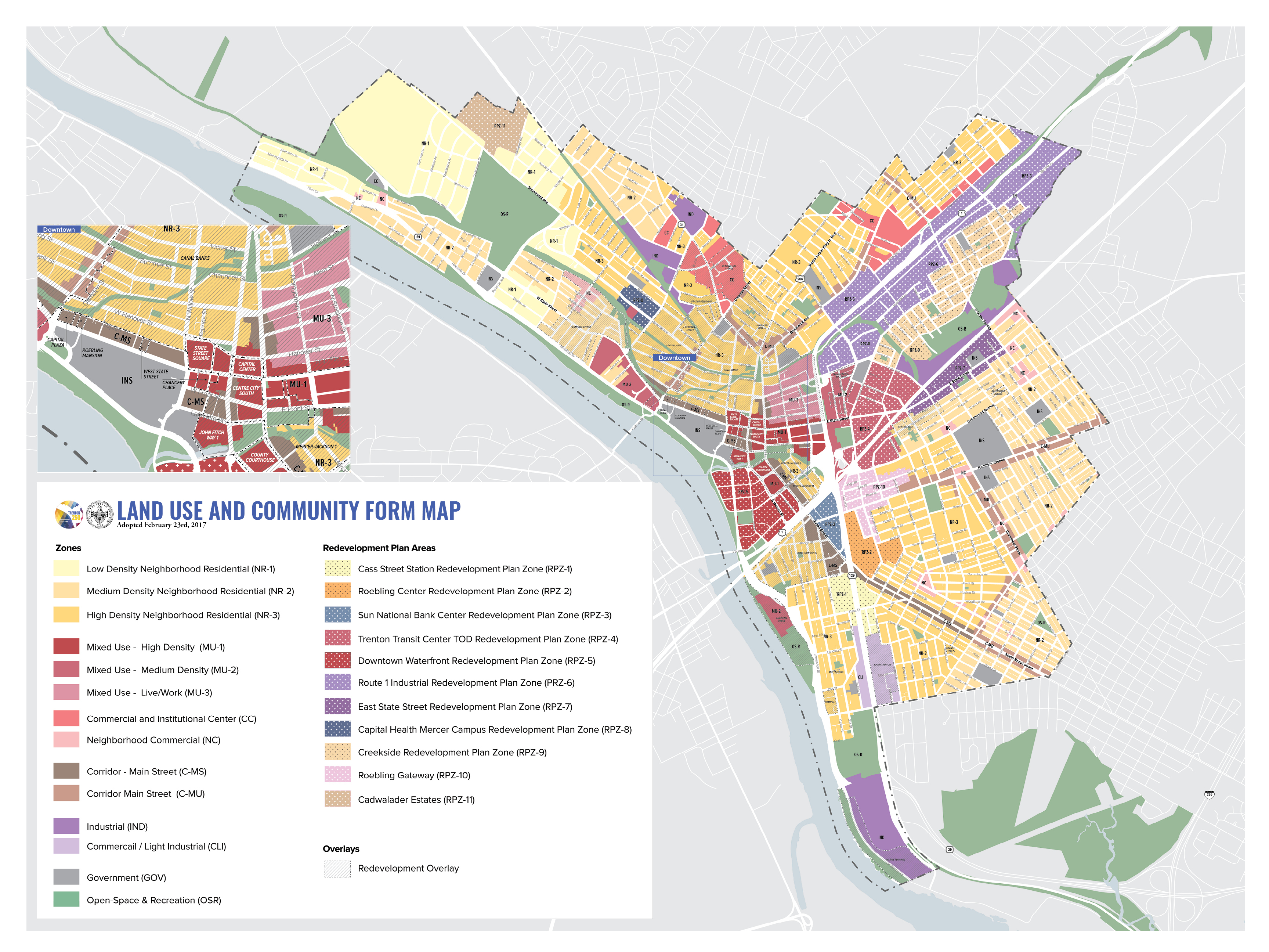
Land Use & Community Form Plan
Join The Mailing List
Introduction
Population Density and Development Intensity Policy
Future Land Use Plan
Zones
Most Popular
Vision & Guiding Principles
Read more about the community-driven vision for Trenton and find out how this was translated into actionable goals, initiatives, and actions.
http://trenton250.org/vision-guiding-principles